Closed Beta

DeepFind Hunter is in closed beta and not yet publicly available. Some capabilities are labeled Beta while their external providers are being configured. Request tester access →

Deepfind Hunter · Closed Beta

Discover history.
One signal at a time.

The treasure-hunting companion built for the hobby — a terrain map you can read, a hunt coach in your pocket, a real detector library, and a find log that measures every hunt. Metal detecting, relic & beach hunting, magnet fishing, and gold prospecting in one app.

Closed beta · App StoreNot yet listed Closed beta · Google PlayNot yet listed
DeepFind Hunter Treasure Map screen with find pins, category filters, SOS and recenter controls over terrain.

One app. Every part of the hunt.

Plan the trip, read the terrain, get better with your gear, log what you dig, and connect with the people who dig it too.

Closed Beta

Honest labels, no fabricated data

Every feature below carries a truthful Live or Beta label. Beta means the feature is in the app but not finished in practice — it may still be waiting on a configured provider or real-device testing, and where it cannot produce a result yet the app says so instead of guessing. Nothing on this site is a mockup: every screenshot is a real in-app capture, and features we have not photographed are shown as text.

Inside DeepFind Hunter

Built around how you actually hunt

Metal detecting, relic & beach hunting, magnet fishing, gold prospecting, terrain analysis, and everything in between.

Live Free & Pro

Treasure Map & GPS Hunt Recording

Know where you're standing. Know where you've been.

Drop a pin the second you find something and filter your map by category so your history builds a picture, not just a pile. Hunt-session recording captures your track on-device, reconciles with your account when you reconnect, and lets you review the walk afterwards — the map a detectorist actually needs.

  • Pin-drop find logging tied to GPS coordinates
  • Category filters: Old Coin, Jewelry, Relic, Magnet Find, and more
  • Hunt-session recording that works with no signal and syncs when you reconnect
  • On-device session review, one-tap recenter, and an SOS control
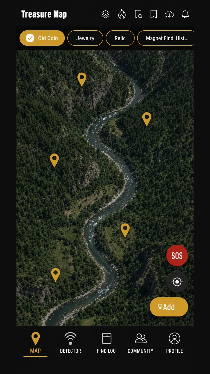
DeepFind Hunter Treasure Map screen showing pins, category filter chips, SOS and recenter buttons over terrain.
Beta Pro

AI LiDAR Terrain Analysis

See what the land is hiding.

AI LiDAR Analysis examines public-domain USGS bare-earth elevation data for terrain anomalies — old cellar holes, foundations, ditches, disturbed ground — and flags them for you to investigate. Every result is labeled possible or suspected. Nothing is ever presented as a confirmed discovery: this is a research aid, not a metal detector for your screen.

  • Flags terrain candidates: cellar holes, foundations, ditches, old roads, disturbed ground
  • Every result labeled "possible" or "suspected", never "confirmed"
  • Built on public-domain USGS 3D Elevation Program (3DEP) data
  • Honest "no LiDAR coverage here" result instead of a guess when 3DEP data is absent
  • Field verification, landowner permission, and local law always come first

Note: Beta. The analysis runs as a server-side pipeline — terrain candidate detection plus a labeling step — that must be deployed and configured before it can return anything; until then the feature reports that analysis is unavailable rather than inventing findings. Coverage is limited to areas with USGS 3DEP data, which means the United States. A separate bare-earth terrain rendering layer exists in the app's layer catalog with no data source attached, and we do not present it as a capability.

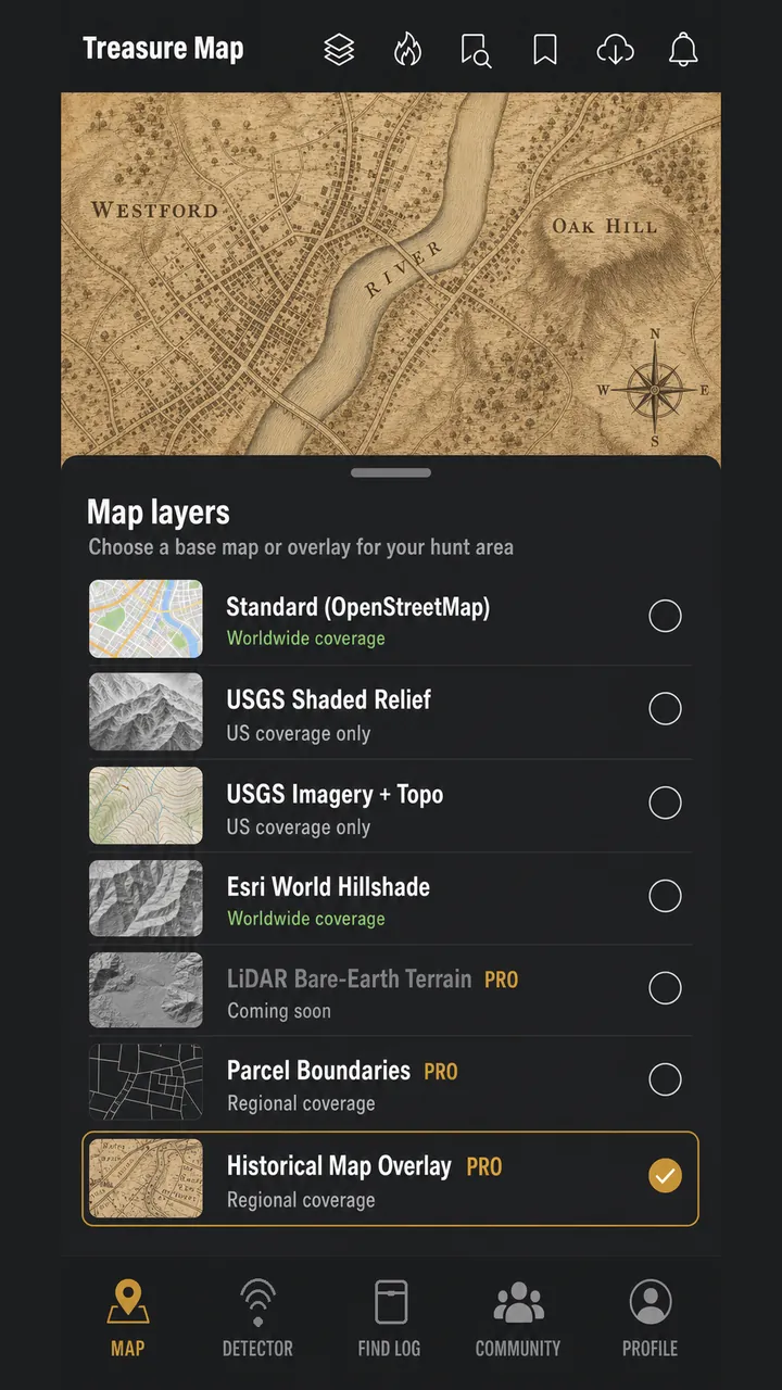
DeepFind Hunter Map Layers screen listing terrain layers and coverage.
Live Free & Pro

Hunt Coach

Ask the coach before you dig.

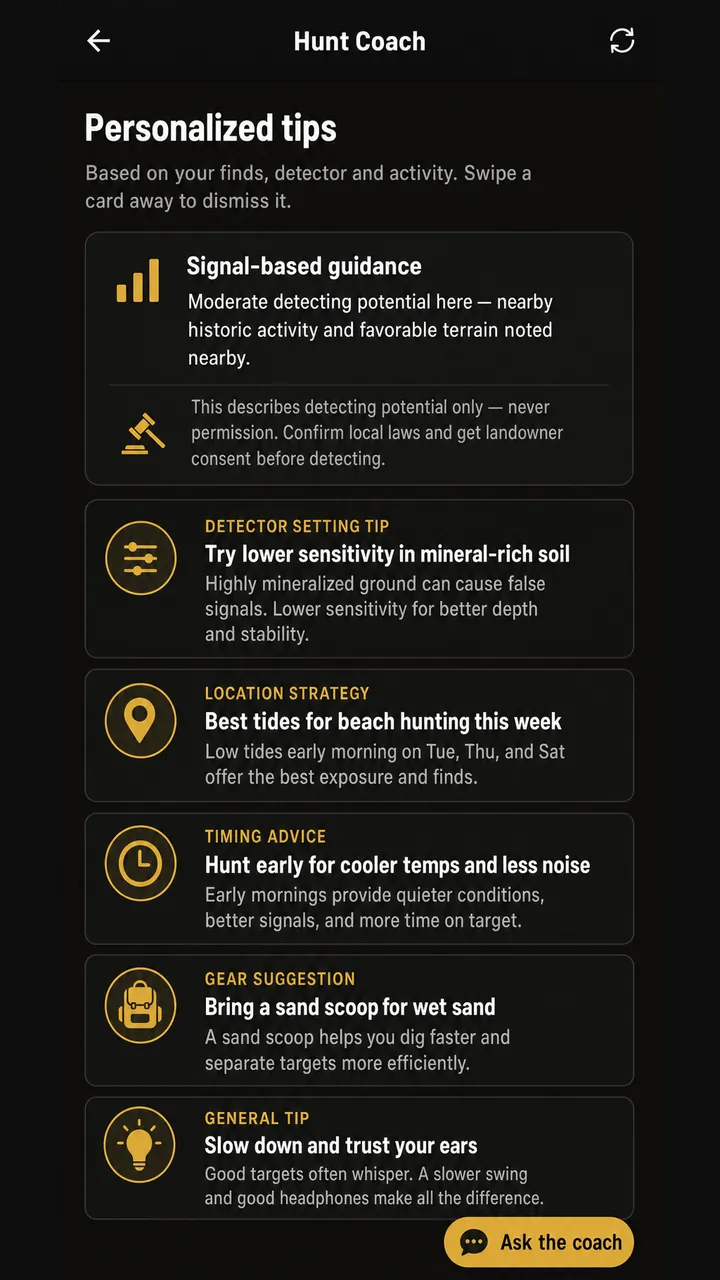
Signal reading tricky? Detector settings feel off? The Hunt Coach gives plain-English guidance — signal interpretation, detector setting tips, location strategy, timing advice, and gear suggestions — drawn from your logged finds and your selected detector, with a chat surface for follow-up questions.

  • Signal-based guidance and detector setting tips
  • Location strategy and timing advice
  • Gear suggestions, plus a chat surface for follow-up questions
  • Guidance describes detecting potential only — never permission

Note: In the current beta the coach runs entirely on your device: tips, signal guidance, and chat replies are generated from a built-in guidance library plus your own logged activity. It does not call an external AI model unless one is configured for a build, so it keeps working offline — but its answers are library-driven rather than open-ended. We describe it as a coach, not as a general-purpose AI assistant.

DeepFind Hunter Hunt Coach screen with personalized tip cards.
Live Free & Pro

Find Log & Find Stats

Every find, logged. Every hunt, measured.

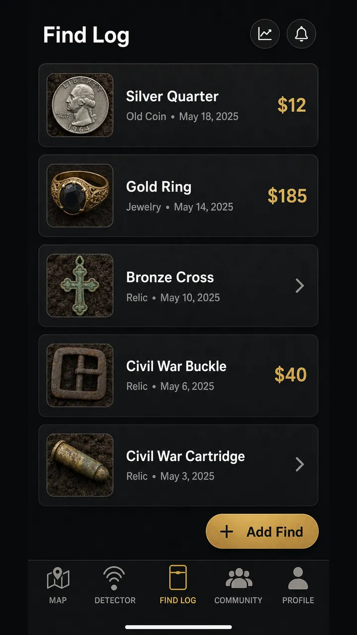
Photo-back every dig — category, depth, value estimate, date, location — and watch your Find Stats dashboard build the story: category breakdown, timeline, most-used detector, and best find. Pro members can export the full log to CSV.

  • Photo-backed Find Log entries with depth in your preferred units
  • Find Stats: category breakdown, timeline, most-used detector, best find
  • Pro CSV export of your full log
  • Self-reported estimates, clearly labeled — never appraisals

Note: Value figures are whatever you enter yourself. They are estimates for your own records and are never an appraisal, authentication, or valuation by DeepFind Hunter. Free accounts store up to 10 entries; Pro is unlimited and adds CSV export.

DeepFind Hunter Find Log screen listing logged finds with photos.
Live Free & Pro

Detector Library & Tools

Your gear, known and organized.

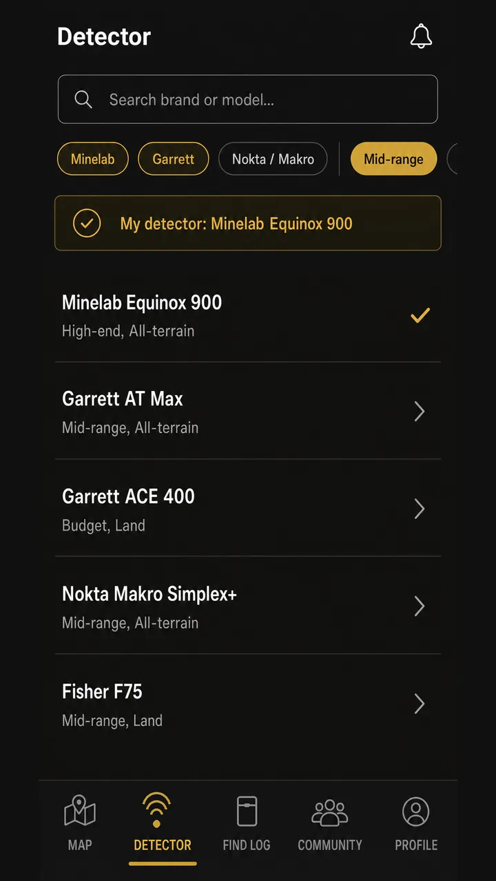
Browse a curated library of real detector models — Minelab, Garrett, Nokta, Fisher and more — with search and brand filtering. Save custom detector profiles with environment guidance so your settings travel with you.

  • Searchable detector model library with brand and terrain filters
  • Custom saved detector profiles with environment guidance
  • Settings guidance for real-world ground conditions

Note: The library ships with a curated set of real, published detector models and grows over time — it is not an exhaustive index of every detector ever made. Free includes the basic library; Pro unlocks the full library and custom profiles.

DeepFind Hunter Detector Library screen with detector models and search.
Live Free & Pro

Community & Clubs

The hobby is better together.

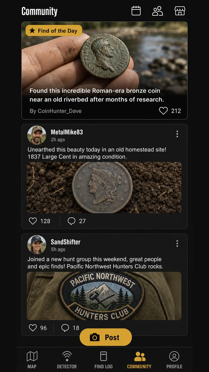
Share your best finds, swap tips, and find your people — a community feed with Find of the Day, a club directory you can search by region, and a progress system that tracks XP, weekly challenges, and achievements. Report and block controls keep it respectful.

  • Community feed with Find of the Day
  • Club Finder — search clubs by region
  • XP, weekly challenges, and achievements
  • User-facing report and block moderation

Note: Community content and the club directory are populated by people, so during a closed beta both will look sparse — early testers are the first posts and the first clubs. Anything you post is visible to other users: never share the precise location of a sensitive or protected site.

DeepFind Hunter Community feed screen with posts and Find of the Day.
Beta Free & Pro

Magnet Fishing

It's not just dirt and sand.

A dedicated Magnet Fishing mode with skill and water-type selectors, gear and coaching guidance, and a dangerous-find safety card pinned first. Magnet-fishing pulls get their own categories in your Find Log and on your map.

  • Skill and water-type selectors with gear guidance
  • Dangerous-find safety guidance pinned before anything else
  • Dedicated magnet-find categories in your Find Log and on the map

Note: Beta. The mode, its guidance content, and its find categories are implemented and covered by automated tests, but it has not completed real-device beta validation, so we label it Beta rather than Live. Magnet fishing carries genuine hazards — unexploded ordnance, weapons, sharp and contaminated metal. If you pull something dangerous, do not move it: leave the area and contact local authorities. A dedicated magnet-fishing photo is still pending, so no fabricated image is shown here.

Real coverage, honestly labeled

What's live, where

Transcribed directly from the app's own Map Layers screen — no invented country counts or coverage percentages.

Map layerCoverageStatus
Standard (OpenStreetMap) The default map. Real tile source, no configuration required. Worldwide Live · Free
Esri World Hillshade Global terrain shading used where USGS data is unavailable. Subject to Esri terms. Worldwide (fallback terrain) Live · Free
USGS Shaded Relief (LiDAR-derived hillshade) Public-domain USGS terrain shading. Outside the US this layer has no data. United States only Live · Free
USGS Imagery + Topo Public-domain USGS aerial imagery with topographic detail. United States only Live · Free
USGS Topo Public-domain USGS topographic basemap. United States only Live · Free

Data sourced from the USGS 3D Elevation Program (public domain) with Esri World Hillshade as a fallback. See Data Sources.

Start free. Upgrade when you're ready.

Simple, honest pricing

Free

$0

  • Treasure Map & GPS hunt recording
  • Hunt Coach guidance
  • Basic Detector Library
  • Up to 10 Find Logs
  • Up to 3 saved locations
  • Community browsing
Request beta access
Best Value

Pro

$9.99/ month

or $79.99 / year — about 33% savings · 30-day Pro trial

  • Everything in Free, unlocked
  • Unlimited Find Logs & saved locations
  • Full Detector Library & custom profiles
  • Full Find Stats with CSV export
  • Research notes, plus AI LiDAR Analysis (Beta)
See full comparison

Your next find is waiting

DeepFind Hunter is in closed beta. Request tester access and help shape the app before public launch.

Request Beta Access
Closed beta · App StoreNot yet listed Closed beta · Google PlayNot yet listed